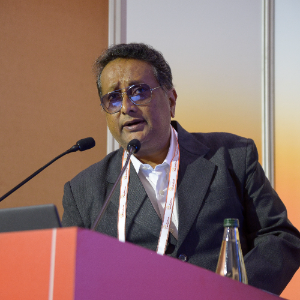
Dr. Parag Jyoti Dutta
Associate Professor
Ph.D. : Gauhati UniversityResearch Interests:
Spatial Data Science, Geostatistics, Machine LearningDate of Joining : Sep 1, 2003
Phone: 6000107366
Email: paragjdutta@cottonuniversity.ac.in
About
Career Profile/Services:
1. GIS Service Executive; Rolta India Limited (27-01-2000 to 27-05-2003)
2. Lecturer; Cotton College (01-09-2003 to 01-09-2009)
3. Assistant Professor (Senior); Cotton College (01-09-2009 to 01-09-2014)
4. Assistant Professor (Stage-3); Cotton College (01-09-2014 to 01-09-2017)
5. Associate Professor; Cotton University (01-09-2017 to Present)
Teaching
Economic Geology, Mineral Exploration, Environmental Geology, Mapping
Experience
Current Academic Profile
Member of faculty, since 2003, in the Department of Geology at Cotton University, Guwahati, a premier institution of higher education in NE India. Work profile involves teaching and academic research. Teaching UG and PG courses in Environmental Geology, Economic Geology, Mineral Exploration, Mapping of Natural Resources since 2003. Research interests include Numerical Modelling of Landslide Processes, Machine Learning & GIS Applications in Landslide Susceptibility Modeling, Geostatistical Ore Body Evaluation, Machine Learning in Mineral Exploration.
Previous Industry Profile
Represented ROLTA INDIA LIMITED, from 2000 to 2003, in the capacity of Product Executive (Mapping/GIS), for providing onsite technical operations support to Imagery Interpretation Teams under the Directorate of Military Intelligence of the Indian Army for mobile and static Photogrammetry units integrated with GIS. These systems, for command and truck-mounted units for mobile formations, are used to create high-resolution 3-D Digital Terrain Models (0.156 × 0.156 m per pixel) from softcopy stereo photos/imageries of the ground collected from spy satellites, drones and low-flying aircraft. Aerial photos and high-resolution satellite imageries are draped over Digital Terrain Models for database creation in GIS to generate a digital library of military targets. Viewshed analysis, line-of-sight analysis, on-screen surveying/mapping play a key role in mission planning, logistics management and acquiring precise spot height information for targeting.
Research Projects
| Sl. No. | Principal Investigator | Co Principal Investigator | Title of the Project | Period | Sponsoring Agency | Sanctioned Amount | Status |
| 1 | Santanu Sarma | Parag J. Dutta | Landslide hazard zoning in the Narakasur Hill of Guwahati city for local development planning – A Pilot Study | 25.09.2014 to 25.09. 2016 | DST (NRDMS), Govt. of India | 13,04,600/- | Completed |
| 2 | Parag J. Dutta | -- | Susceptibility assessment of rainfallinduced shallow landslides in the Narakasur Hill of Guwahati by a physically-based modelling approach | 28. 03. 2014 to 28.03. 2016 | UGC, Govt. of India | 4,79,389/ | Completed |
Research Projects
| Sl. No | Name of the Project | Name of the Principal Investigator(PI) | Name of the Co-PI | Name of the Funding Agency | Type (Government/Non-Government) | Year | Funds Sanctioned (INR in lakhs) | Duration of the Project |
|---|---|---|---|---|---|---|---|---|
| 1 | Development of algorithms and software plugins for Geostatistical Co-Simulation and Regionalized Classification, for aiding deposit scale modelling Status: Ongoing |
Dr. Parag Jyoti Dutta, Associate Professor, Department of Geology, Cotton University, Guwahati 781001, India | Dr. V. Kameshwara Rao, General Manager (Geo-Statistics), Resource Planning Department, NMDC Ltd., Hyderabad - 500028, India | Technology Innovation in Exploration & Mining Foundation (TEXMiN): a section-8 company created by the DST, Govt. of India, established at IIT (ISM) Dhanbad | Government | 2024 | 19.39 Lakhs | 24 Months |
Research paper publications
2025
1. Abhishek Borah, Parag Jyoti Dutta, Xavier Emery, Geostatistically Enhanced Learning for Supervised Classification of Wall-Rock Alteration Using Assay Grades of Trace Elements and Sulfides, Minerals , vol. 15, 01-30, 11 (1128), 2075-163X, 2025 https://doi.org/10.3390/min15111128
2024
1. Parag Jyoti Dutta and Xavier Emery, Classifying rock types by geostatistics and random forests in tandem, Machine Learning: Science and Technology [IF: 6.8], vol. 5, 1 - 25, 2, ISSN: 2632-2153, 2024 https://doi.org/10.1088/2632-2153/ad3c0f
2021
1. Karishma Sarma and Parag Jyoti Dutta, Soil Erosion Estimation of Palasbari in Northeast India by RUSLE Model, Bulletin of Pure and Applied Sciences-Geology, vol. 40, 129-141, 2, ISSN: 2320-3234, 2021 https://doi.org/10.5958/2320-3234.2021.00012.3
2019
1. Parag Jyoti Dutta, Jayanta Jivan Laskar, and Santanu Sarma, A Field Verification Based Statistical Approach toward Landslide Susceptibility Assessment, Bulletin of Pure and Applied Sciences-Geology, vol. 38, 266-273, 2, ISSN: 2320-3234, 2019 https://doi.org/10.5958/2320-3234.2019.00020.9
2017
1. Parag Jyoti Dutta, Santanu Sarma, Jayanta Jivan Laskar, Predicting the Spatial Distribution of Rain-Induced Shallow Landslides by applying GIS and Geocomputational Techniques: A Case Study from North East India, International Journal on Recent and Innovation Trends in Computing and Communication, vol. 5, 1306–1319, 5, ISSN: 2321-8169, 2017 https://doi.org/10.17762/ijritcc.v5i5.698
2016
1. Maria Giuseppina Persichillo, Parag Jyoti Dutta, Massimiliano Bordoni, Claudia Meisina, Carlotta Bartelletti, Michele Barsanti, Roberto Giannecchini, Giacomo D'Amato Avanzi, Yuri Galanti & Andrea Cevasco, Nonlinear regression technique to assess the landslide susceptibility of the Kalapahar hill, Guwahati, Assam State (India), RENDICONTI ONLINE DELLA SOCIETÀ GEOLOGICA ITALIANA, vol. 41, 179-182, ISSN: 2035-8008, 2016 https://doi.org/10.3301/ROL.2016.123
Research paper publications till 2021
1. Dutta PJ, Sarma S, Laskar JJ (2017) Predicting the Spatial Distribution of Rain-Induced Shallow Landslides by applying GIS and Geocomputational Techniques: A Case Study from North East India. International Journal on Recent and Innovation Trends in Computing and Communication (ISSN: 2321-8169), 2017, Vol. 5, Issue 5, pp. 1306–1319.
2. Sarma S, Dutta PJ, Borgohain R (2017) Susceptibility Assessment of Rainfall-induced Shallow Landslides using a GISsupported Deterministic Analysis – A Pilot Study. International Journal of Advanced Remote Sensing and GIS (ISSN: 2320 – 0243), 2017, Vol 6, Issue 1, pp. 2281- 2291.
3. Persichillo MG, Dutta PJ, Bordoni M, Meisina C, Bartelletti C, Barsanti M, Giannecchini R, Avanzi GD, Galanti Y, Cevasco A (2016) Nonlinear regression technique to assess the landslide susceptibility of the Kalapahar hill, Guwahati, Assam State (India). Rendiconti Online della Società Geologica Italiana (ISSN:2035-8008), 2016, Vol. 41, pp. 179-182.
Dutta PJ (2015) Assessment of groundwater potential in a part of the Vedganga watershed of Kolhapur district, Maharashtra, by a GIS-based Bivariate statistical method. International Journal of Advancement in Earth & Environmental Sciences (ISSN: 2321 – 9149), 2015, Vol. 3, Issue 1, pp. 22-29.
Dutta PJ, Sarma S (2013) Landslide Susceptibility Zoning of the Kalapahar Hill, Guwahati, Assam State, (India), using a GIS-Based Heuristic Technique. International Journal of Remote Sensing & Geoscience (ISSN: 2319-3484), 2013, Vol 2, Issue 2, pp. 49 – 55.
Awards
Accredited with “Top Performing Mentor” in India for January-June 2022 session by NPTEL for mentoring an M.Sc. 2nd Semester batch (2022) of students for a massive open online course (MOOC) entitled “Mineral Resources: Geology, Exploration, Economics, and Environment.”
Other Information
Association with Professional Bodies:
1. Member of the American Association for the Advancement of Science (AAAS) AAAS Member Number: 41761151
Any other information:
1. Reviewer for the "Journal of Earth System Science" of Indian Academy of Sciences
2. Reviewer for the journal "Landslides" published by Springer
